SuchiGopal
.01

ABOUT

PERSONAL DETAILS
675 Commonwealth Ave., Boston, MA 022115, Office 459
Suchi@bu.edu
+1 (617) 353-5744
Hello. I am a Professor Researcher Leader Dreamer
I am passionate about research utilizing
GIS, mapping, and geospatial models
Available for questions

BIO

ABOUT ME

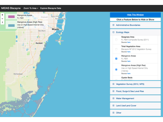
My research is multidisciplinary dealing with spatial analysis and modeling, GIS, data mining and information visualization and artificial neural networks. I have applied spatial analysis to address a variety of problems in biology, environmental science, public health and business. I have also worked on uncertainty issues related to GIS. I have used neural networks for pattern classification, estimation and mixture modeling. My current funded research includes development of a Model Integrated Decision Analysis System (MIDAS) for Cambodia and Biscayne Bay, Florida. Coupling of green and gray infrastructure in Boston, and mapping health service delivery in Kenya. I am funded by the National Science Foundation on a GK-12 grant—Global Change Initiative—Research and Education (GLACIER) focusing on outreach to middle schools in the Boston area. In addition, I am funded by the MacArthur Foundation on assessing the impact of climate change on food security and biodiversity in Cambodia.

FACTS

NUMBERS ABOUT ME

920
CUPS OF COFFEE
65
PROJECTS COMPLETED
2965
STUDENTS TAUGHT
235
WORKSHOPS

.02

CV/RESUME

Download Detailed List Here

  • EDUCATION
  • 1983
    1988
    Santa Barbara, CA

    PhD in Geograhpy

    University of California at Santa Barbara

  • 1981
    1983
    Madras, India

    MPhil in Geography

    Madras University

  • 1979
    1980
    Madras, India

    BEd

    Madras University

  • 1977
    1979
    Madras, India

    MSc in Geography

    Madras University

  • 1974
    1977
    Madras, India

    BA in Geography

    Madras University

  • ACADEMIC AND PROFESSIONAL POSITIONS
  • 2016
    2016
    Vienna, Austria

    Visiting Professor

    Vienna University

    Vienna University of Economics and Business
  • 2010
    Present
    Boston, MA

    Research Professor

    Boston University

    Pardee Center for the Study of the Longer-Range Future
  • 2003
    Present
    Boston, MA

    Professor

    Boston University

    Department of Geography
  • 2008
    2009
    Boston, MA

    Education Thrust Leader

    Boston University

    Education Thrust Leader NSF Center of Excellence for Learning in Education, Science, and Technology (CELEST)
  • 2001
    2011
    Boston, MA

    Research Associate Professor

    Boston University

    CNS Technology Lab
  • 2001
    2003
    Boston, MA

    Research Associate Professor

    Boston University

    Boston University Center for Leading in a Dynamic Economy (BUILDE), School of Management
  • 1996
    2003
    Boston, MA

    Associate Professor

    Boston University

    Department of Geography
  • 1993
    1997
    Vienna, Austria

    Visiting Research Fellow

    Wirtchafsuniversitat

    Department of Social and Economic Geography
  • 1989
    1995
    Boston, MA

    Assistant Professor

    Boston University

    Department of Geography
  • 1989
    1989
    Santa Barbara, CA

    Post-Doctoral Fellow

    UCSB

    National Center for Geographic Information Analysis
.03

PUBLICATIONS

Download Detailed List Here

PUBLICATIONS LIST
1990

The Accuracy of Spatial Databases

London

Francis and Taylor, London, 1990.

Book Goodchild, M., and Gopal, S. (Eds.).
1993

Neurocomputing-a new paradigm for geographic information processing

Environment and Planning A

Environment and Planning A, 25 757--760

Journals M M Fischer,S Gopal
1988

Magnitude and spatial distribution of combustible materials in San Jose area, California

Fire and Materials

Fire and Materials 12 95--108

Journals D Simonett,T Barrett,S Gopal,F Holsmuller,H Veregin
1990

Human way-finding in an urban environment: a performance analysis using a computational processing approach

Environmental and Planning A

Environmental and Planning A 22 169--191

Journals S Gopal,T Smith
2016

Characterizing urban landscapes using fuzzy sets. Computers

Environment and Urban Systems

Environment and Urban Systems, 57, 212-223.

Journals Gopal, S., Tang, X., Phillips, N., Nomack, M., Pasquarella, V., & Pitts, J.
2017

Spatial heterogeneity of climate change as an experiential basis for skepticism

Proceedings of the National Academy of Sciences

PNAS, Proceedings of the National Academy of Sciences 114(1) 67-71.

Journals Kaufmannan, R., Mann, M., Gopal,S., Liederman, J., Howe, P., Pretise, F., Tang, Xiaojing, and Gilmore, M
1996

Sensitivity of neural networks to subpixel land-cover mixtures in coarse-resolution satellite data

Remote Sensing of Environment

Remote Sensing of Environment Remote Sensing of Environment 58 329--343

Journals A Moody,S Gopal,A H Strahler
1989

NAVIGATOR: A psychologically based model of environmental learning through navigation

Journal of Environmental Psychology

Journal of Environmental Psychology 9 309--331

Journals S Gopal,R Klatzky,T Smith
1996

Remote sensing of forest change using artificial neural networks

IEEE Transactions on Geoscience and Remote Sensing

IEEE Transactions on Geoscience and Remote Sensing 34 398--404

Journals S Gopal,C E Woodcock
1996

Learning in single hidden layer feedforward neural network models: backpropagation in a spatial interaction modeling context

Geographical Analysis

Geographical Analysis 28 38--55

Journals S Gopal,M Fischer
1996

Evaluation of the potential for providing secondary labels in vegetation maps

Photogrammetric Engineering and Remote Sensing

Photogrammetric Engineering and Remote Sensing 62 393--399

Journals C E Woodcock,S Gopal,W Albert
2000

Fuzzy set theory and thematic maps: accuracy assessment and area estimation

International Journal of Geographical Information Systems

International Journal of Geographical Information Systems 14 153--172

Journals C E Woodcock,S Gopal
1997

ART networks in Remote Sensing

IEEE Transactions on Geoscience and Remote Sensing

IEEE Transactions on Geoscience and Remote Sensing 35 308--325

Journals G Carpenter,M Gjaja,S Gopal,C Woodcock
1994

Theory and methods for accuracy assessment of thematic maps using fuzzy sets

Photogrammetric Engineering and Remote Sensing

Photogrammetric Engineering and Remote Sensing 60 181--188

Journals S Gopal,C Woodcock
1999

The role of attention in spatial learning during simulated route navigation

Environment and Planning A

Environment and Planning A 31 1459--1472

Journals Albert W Reinitz,M Beusmans,J,S Gopal
1997

Forward and inverse modeling of canopy directional reflectance using a neural network

International Journal of Remote Sensing

International Journal of Remote Sensing 19 453--471

Journals A Abuelgasim,S Gopal,Strahler
1995

Predicting sunspot cycles using feedforward neural networks

Geographical Analysis

Geographical Analysis 27 42--60

Journals S Gopal,L Scuderi
1999

The significance of synoptic patterns identified by the Kirchhofer technique: A Monte Carlo approach

International Journal of Climatology

International Journal of Climatology 19 619--626

Journals R K Kaufmann,S E Snell,S Gopal,R Dezzani
2014

Measuring community integration using Geographic Information Systems (GIS) and participatory mapping for people who were once homeless

Health & place

Health & place, 27, 92-101, 2014

Journals Chan, D. V., Helfrich, C. A., Hursh, N. C., Rogers, E. S., & Gopal, S
1997

Evaluation of neural pattern classifiers for a remote sensing application

Geographical Systems

Geographical Systems 4 195--225

Journals M M Fischer,S Gopal,P Staufer,K Steinocher
1995

Neural network models and interregional telephone traffic: comparative performances between multilayer feedforward networks and the conventional spatial interaction model

Journal of Regional Science

Journal of Regional Science Journal of Regional Science 34 503--527

Journals M Fischer,S Gopal
1999

Fuzzy ARTMAP classification of global land cover from the 1 degree AVHRR data set

Remote Sensing of the Environment

Remote Sensing of the Environment 67 230--243

Journals S Gopal,C Woodcock,A Strahler
2009

Spatial analysis of malaria incidence at the village level in areas with unstable transmission in Ethiopia

International Journal of Health Geographics

International Journal of Health Geographics 8:5

Journals Yeshiwondim, Asnakew K., Gopal, S., Hailemariam, Afework T., Dengela, Dereje O. and Hrishikesh P. Patel
2001

ARTMAP neural networks for image processing, interpretation, visualization

Massive Computing

Chapter in V. Kumar, R. Grossman, C. Kamath, and R. Namburu (Eds.) Massive Computing

Book Chapters Liu, W., Gopal, S., and Woodcock, C.
2001

Visualization Based on the Fuzzy ARTMAP Neural Network for Mining Remotely Sensed Data

Geographic Data Mining and Knowledge Discovery

Invited Chapter in Harvey J. Miller and Jiawei Han (eds.), Geographic Data Mining and Knowledge Discovery, pp. 315-335

Book Chapters Gopal, S., W. Liu and Woodcock, C.
1999

Change detection using adaptive neural networks: Environmental damage assessment after the Gulf War

Remote Sensing of the Environment

Remote Sensing of the Environment 70 208--223

Journals A Abuelgasim,W D Ross,S Gopal,C E Woodcock
2000

A note on procedures used for accuracy assessment in land cover maps derived from AVHRR data

International Journal of Remote Sensing

International Journal of Remote Sensing 21 1073--1077

Journals M A Friedl,C Woodcock,S Gopal,D Muchoney,A H Strahler,C Barker-Schaaf
2005

Multiscale, multigranular statistical image segmentation

Journal of the American Statistical Association

Journal of the American Statistical Association 100 1358--1369

Journals E D Kolaczyk,J Ju,Gopal S
2007

Patterns in forest clearing along the Appalachian Trail corridor

Photogrammetric Engineering and Remote Sensing

Photogrammetric Engineering and Remote Sensing 73 783--791

Journals D Potere,C E Woodcock,A Schneider,M Ozdogan,A Baccini,S Gopal
2006

Using a Context Approach to Process Statistical Queries in Raster Data: An Extended Abstract

SSTDM ‘06

(SSTDM ‘06), in conjunction with the IEEE 6th International Conference on Data Mining (ICDM ‘06), Hong Kong, December 18, 2006 (Selectivity: 1 out of 3). (Selected as one of the best papers and invited for an extended journal publication in the Knowledge and Information Systems (KAIS))

CONFERENCES Gandhi, J. M. Kang, S. Shekhar, J. Ju, E. D. Kolaczyk, S. Gopal
2011

MIDAS: A Spatial Decision Support System for Monitoring Marine Management Areas

International Regional Science Review

International Regional Science Review, April 2011 191--214

Journals H Patel,S Gopal,K Kaufman
2005

Spatial Analysis of 1991 Gulf War Troop Locations in Relationship with Postwar Health Symptom Reports Using GIS Techniques

Transactions in GIS

Transactions in GIS 9 381--396

Journals Proctor SP,S Gopal,A Imai,J Wolfe,D Ozonoff,White RF
2005

Subpixel burn detection in Moderate Resolution Imaging Spectroradiometer 500-m data with ARTMAP neural networks

Journal of Geophysical Research

Journal of Geophysical Research Vol. 110, 2005

Journals Shabanov, N. V., Lo, K., Gopal, S., and R. B. Myneni
2004

Uncertainty and Confidence in Land Cover Classification Using a Hybrid Classifier Approach

Photgrammetric Engineering and Remote Sensing

Photgrammetric Engineering and Remote Sensing 70 963--972

Journals Weiguo Liu,Sucharita Gopal,Curtis E Woodcock
2001

Multisensor/resolution Framework for Landcover Characterization

Photgrammetric Proceedings of 4th Annual Conference on Information Fusion, Montrea

Proceedings of 4th Annual Conference on Information Fusion, Montreal, August, 2001, WeC2-11-16, 2001

Journals Liu, W., Gopal, S., and C.E. Woodcock
2000

Application of the MODIS global supervised classification model to vegetation and land cover mapping of Central America

International Journal of Remote Sensing

International Journal of Remote Sensing 21 1115--1138

Journals D Muchoney,J Borak,M Chi,M Friedl,S Gopal,J Hodges,N Morrow,A Strahler,A
2003

Gaussian mixture discriminant analysis and sub-pixel land cover classification in remote sensing

Remote Sensing of Environment

Remote Sensing of Environment 84 550--560

Journals J Ju,E D Kolaczyk,S Gopal
2004

ART-MMAP: a neural network approach to sub-pixel classification

IEEE Transactions on Geoscience and Remote Sensing

IEEE Transactions on Geoscience and Remote Sensing, 42(9), 2004

Journals Liu, W., Karen Seto, Elaine Wu, Sucharita Gopal and Curtis Woodcock
2012

Global synthesis of Searchlight reports using knowledge discovery and visualization

Foresight

Foresight, v14 i6 468--488

Journals Sucharita Gopal
1996

Optimizing rules for labeling polygons for per-pixel classification using fuzzy sets

Geographical Systems

Geographical Systems 2 83--101

Journals S Gopal,C Woodcock,G Unis
1994

Mapping forest vegetation using Landsat TM imagery and a canopy reflectance model

Remote Sensing of Environment

Remote Sensing of Environment 50 240--254

Journals C E Woodcock,J Collins,S Gopal,V Jakabhazy,X Li,S Macomber,S Ryherd,Y Wu,V J Harward,J Levitan,R Warbington
1999

A Neural Network Method for Mixture Estimation for Vegetation Mapping

Remote sensing of the Environment

Remote sensing of the Environment 70 138--152

Journals G Carpenter,S Gopal,S Martens,C Woodcock
1999

A neural network method for efficient vegetation mapping

Remote sensing of the Environment

Remote sensing of the Environment 70 326--338

Journals G Carpenter,S Gopal,S Macomber,S Martens,C Woodcock,J Franklin
1992

Gender-related differences in spatial abilities

Progress in Human Geography

Progress in Human Geography 16 315--342

Journals C Self,S Gopal,R Golledge,S Fenstermaker
1996

Classification of ASAS multiangle and multispectral measurements using artificial neural networks

Remote Sensing of Environment

Remote Sensing of Environment 57 79--87

Journals A Abuelgasim,S Gopal,J Irons,A Strahler
2017

Spatial heterogeneity of climate change as an experiential basis for skepticism

114 67--71

Journals R Kaufmannan,M Mann,S Gopal,J Liederman,P Howe,F Pretise,Tang Xiaojing,M Gilmore
2010

The economics of cropland conversion in Amazonia: The importance of agricultural rent

Ecological Economics

Ecological Economics, Elsevier, vol. 69(7), pp 1503-1509

Journals Mann, Michael L. & Kaufmann, Robert K. & Bauer, Dana & Gopal, Sucharita & Vera-Diaz, Maria Del Carmen & Nepstad, Daniel & Merry, Frank & Kallay, Jennifer & Amacher, Gregory S..
2014

Pasture conversion and competitive cattle rents in the Amazon

Ecological Economics

Ecological Economics, Elsevier, vol. 97(C), pages 182-190, 2014

Journals Mann, Michael L. & Kaufmann, Robert K. & Bauer, Dana Marie & Gopal, Sucharita & Nomack, Mallory & Womack, Jesse Y. & Sullivan, Kerry & Soares-Filho, Britaldo S.
2012

Ecosystem Service Value and Agricultural Conversion in the Amazon: Implications for Policy Intervention

Environmental & Resource Economics

Environmental & Resource Economics, European Association of Environmental and Resource Economists, vol. 53(2), pages 279-295, October, 2012

Journals Michael Mann & Robert Kaufmann & Dana Bauer & Sucharita Gopal & James Baldwin & Maria Del Carmen Vera-Diaz.
FEB 2012

Connecting the Dots: Information Visualization and Text Analysis of the Searchlight Project Newsletters.

Pardee Center for the Study of the Longer-Range Future

Pardee Center for the Study of the Longer-Range Future 36 February 2012 (36 pages). ISBN: 978-1-936727-05-6, 2012

Journals S Gopal,A Najam
1990

NAVIGATOR: A psychologically based model of human way-finding in an urban environment

Spatial Choices and Processes,

in M. Fischer, P. Nijkamp and Y. Papageorgiou (Eds.), Spatial Choices and Processes, pp. 169-200, North Holland Press: Amsterdam, 1990

Journals S Gopal,T Smith
2005

On the choice of spatial and categorical scale in remote sensing land cover characterization.

Remote Sensing of Environment

Remote Sensing of Environment 96--1

Journals J Ju,S Gopal,E D Kolaczyk
2001

Monitoring temperate conifer forests with Landsat TM: A new look at classification generalization

Remote Sensing of Environment

Remote Sensing of Environment 77(3) 241--250

Journals M Pax-Lenney,C E Woodcock,S Gopal,S Macomber
1996

Neural network models of cognitive map

The Construction of Cognitive Map

The Construction of Cognitive Map 69--85

Journals S Gopal
2009

Error in GIS (propagation and modeling

International Encyclopedia of Human Geography

International Encyclopedia of Human Geography 586--594

Journals S Gopal
2001

Fuzzy ARTMAP - A Neural Classifier for Multispectral Image Classification

Geocomputational Modelling : Techniques and Applications (Advances in Spatial Science),

Geocomputational Modelling : Techniques and Applications (Advances in Spatial Science), pp. 165-194. Springer Verlag: Heidelberg, 2001,

Book Chapters S Gopal,M Fischer
2007

The evolving social geography of blogs

Societies and Cities in the Age of Instant Access

Societies and Cities in the Age of Instant Access 275--294

Journals S Gopal
1994

The application of artificial neural networks in remote sensing and pattern recognition

Pathways to Human Ecology

Pathways to Human Ecology 17--35

Journals S Gopal,M Fischer
1997

Fuzzy ARTMAP - A Neural Classifier for Multispectral Image Classification

Recent Developments in Spatial Analysis: Spatial Statistics, Behavioural Modelling and Computational Intelligence

Recent Developments in Spatial Analysis: Spatial Statistics, Behavioural Modelling and Computational Intelligence, 306--35

Journals S Gopal,M Fischer
2000

Spatial interpolation of GCM forecasts using artificial neural networks

Journal of Climate

Journal of Climate 13--886

Journals S E Snell,S Gopal,R K Kaufmann
1997

Fuzzy ARTMAP - A Neural Classifier for Multispectral Image Classification

Recent Developments in Spatial Analysis: Spatial Statistics, Behavioural Modelling and Computational Intelligence

Fischer, M.M. and Getis, A. (eds.): Recent Developments in Spatial Analysis: Spatial Statistics, Behavioural Modelling and Computational Intelligence, pp. 306-35. Springer, Heidelberg, 1997.

Book Chapters M M Fischer,A Getis
1997

Evaluation of mixture estimation methods for vegetation mapping

Technical Report

Report CAS/CNS-97-014, Boston University, 1997.

Journals M M Fischer,A Getis
2001

Land Cover Mapping from MODIS: First Results and Future Directions

8th International Symposium on Physical Measurements and Signatures in Remote Sensing, ISPRS

8th International Symposium on Physical Measurements and Signatures in Remote Sensing, ISPRS 3--8

Journals M A Friedl,D McIver,J C F Hodges,X Zhang,S Gopal,C E Woodcock,A H Strahler,Land
2003

Mathematical Models and Quantitative Methods

Geography in America at the Dawn of the 21st Century

Geography in America at the Dawn of the 21st Century. Oxford University Press, 442–457, 2003.

Journals Legates, D.R., S. Gopal, and P. Rogerson
2009

Multiscale Landcover Characterization using a Neural Network

Spatial Modeling and Analysis

in Fischer and Getis (Eds) Spatial Modeling and Analysis, Springer: Hiedelberg, Germany, Pages 521-542, 2009

Journals S Gopal,W Liu,C Woodcock
MAY 2010

Sub-Saharan Africa at Cross-Roads: A quantitative analysis of regional development

THE PARDEE PAPERS

THE PARDEE PAPERS No. 10

Journals Tyler, Zachary C. and S. Gopal
2008

Modeling the spatial patterns of addiction in the US. Geography and Drug Addiction, edited by

Geography and Drug Addiction

Geography and Drug Addiction 415--437

Journals S Gopal,M Vanelli,M Adams
2014

Accessibility patterns and community integration among previously homeless adults: A Geographic Information Systems (GIS) approach

Social Science & Medicine

Social Science & Medicine, 2014, vol. 120, issue C, pages 142-152, 2014.

Journals Chan, Dara V., Gopal, S., and C. A. Helfrich
2015

“Modeling Coastal and Marine Environmental Risks in Belize using MIDAS”.

Coastal Management

Coastal Management, 43(3), 217-237, 2015.

Journals Gopal, S., Kaufman, L., Holden, C., Ribera, M., Pasquarella, V., Shank, B., & Pitts, J
2013

Revisiting the weather effect on energy consumption; implications for the impact of climate change

Energy Policy

Energy Policy v62 1377--1384

Journals Kaufmann RK,S Gopal,X Tang,S M Raciti,PE Lyons,N Geron,F Craig
2013

An Ecosystem Accounting Framework for Marine Ecosystem-Based Management

The Sea

The Sea Volume 16: Marine Ecosystem-Based Management

Journals Irit Altman, Roel Boumans, Joe Roman, Suchi Gopal, and Les Kaufman
2001

Visualization Based on the Fuzzy ARTMAP Neural Network for Mining Remotely Sensed Data, Invited Chapter

315--335

Journals S Gopal,W Liu,C Woodcock
1999

Artificial Neural Networks for Detecting Forest Change

Information Processing for Remote Sensing

Information Processing for Remote Sensing 225--236

Journals S Gopal,C E Woodcock
.04

RESEARCH

AREAS OF RESEARCH

NAVIGATOR

Spatial Analysis, Spatial Modeling & GIS

My work related to spatial navigation involved building an AI system that could simulate human spatial learning in large urban spaces. The agent called the NAVIGATOR learned landmark, route and area knowledge of urban environments. My early research is now in vogue with autonomous navigation systems and driverless cars.

NEURAL NETWORKS

Spatial Analysis, Spatial Modeling & GIS

Along with colleagues, I have applied neural networks for a variety of contexts including landcover classification, change detection, predicting phone calls made between different towns in Austria, as well as finding risk to trees due to gas leaks, and characterizing FEWS (Food, Energy, & Water Securities).

Multi-stakeholder Spatial Decision Platform

Spatial Analysis, Spatial Modeling & GIS

Our research team has been involved in building a multi-stakeholder Modeling Integrated Decision Analysis System called MIDAS for various marine protected regions of the world including Belize and Massachusetts. Over the last three years, we have built MIDAS for terrestrial system of the Tonle Sap in Cambodia. We have conducted several workshops in Cambodia for various stakeholders. Currently we are also working on Biscayne National Park that will incorporate the impact of the latest hurricane Jose.

Fuzzy sets & Fuzzy inference

Spatial Analysis, Spatial Modeling & GIS

We have used fuzzy sets and fuzzy inference for accuracy assessment that is now used by the US Forest Service Gap Analysis. Recently, we have designed a fuzzy inference system to denote urban index (urban-suburban-rural gradient).

GWR

Spatial Analysis, Spatial Modeling & GIS

We have applied Geographically Weighted regression for spatial hedonic modeling. We predict the price of a home in various towns of Massachusetts using a number of independent variables.

Coupling of Green and Gray Infrastructure

Spatial Analysis, Spatial Modeling & GIS

GIS does not map and integrate gray infrastructure underground with surface features. I received funding from NSF (CNH grant with Nathan Phillips, PI) to do this mapping. We have conducted a workshop and students Yaxiong Ma and Jessica Wright are demonstrating the underground infrastructure of Dorchester Avenue in Boston via a Virtual Reality demo.

Zamcat

Public Health

I worked with Professor David Hammer, BU Global Health on analyzing the availability and accessibility of health facilities with respect to professional delivery services in Kalomo, Zambia. Four hypothetical case scenarios illustrate how spatial variance of availability, accessibility, and functionality of health facilities impact access and utilization of services.

Heat Strokes India

Public Health

The effects of extreme heat waves experienced in India have resulted in an increase in counts of premature mortality. We show that, over the past 40 years, India has experienced an increase in the intensity, duration, and frequency of extreme heat wave events as a direct result of climate change.

Maternal Health in Kenya

Public Health

I am working with Professor Lawrence Were, and students for detailing maternal health access and delivery in Kenya.

Food Security in Cambodia

Public Health

We are analyzing impact on health resulting from food insecurity in cambodia.

NSF GK 12

Education Outreach

Boston University STEM fellows worked on our NSF GK12 grant (2010-2017) with middle school teachers and posted a suite of curriculum modules on this website. We have special curriculum for Belize and Massachusetts (visit: http://gk12glacier.bu.edu/) Systems Modeling Curriculum is also available on request. We have a number of exercises addressing different aspects of systems models for urban resiliency.

Characterizing Mangroves in Belize

Remote Sensing

Agriculture in Egypt

Remote Sensing

Our team consisting of Professors Magaly Koch and Faroukh El-Baz and Gloria Molina at BU Center for Remote Sensing has used Landsat time series analysis for monitoring agriculture around the Nile Valley in Egypt.

Landcover change Siem Reap

Remote Sensing

Our team consisting of Professors Magaly Koch and Faroukh El-Baz and Gloria Molina at BU Center for Remote Sensing has used Landsat time series analysis for monitoring agriculture around the Nile Valley in Egypt.

Lake Victoria

Remote Sensing

Our team consisting of Professors Magaly Koch and Faroukh El-Baz and Gloria Molina at BU Center for Remote Sensing has used Landsat time series analysis for monitoring agriculture around the Nile Valley in Egypt.

RESEARCH PARTNERS

NATHAN PHILLIPS

PROFESSOR

Nathan Phillips is Professor of Earth and Environment at Boston University. His research focuses on physiological mechanisms that regulate water, carbon, and energy exchanges between plants/ecosystems and the environment.

LES KAUFMAN

PROFESSOR

Our lab is devoted to understanding the processes that create, maintain, extinguish, and conserve aquatic biodiversity. Our work includes marine, freshwater, and watershed ecosystems in temperate and tropical environments.

ROBERT KAUFMAN

PROFESSOR

My research focuses on three areas; global climate change, world oil markets, and land-use changes. Research on global climate change includes topics such as are humans causing climate co change and how will changes in climate affect natural ecosystems and human well-being?

MAGALY KOCH

ASSOCIATE PROFESSOR

Dr. Magaly Koch is a geologist specialized in the application of Remote Sensing and Geographic Information Systems in the study of groundwater resources and environmental change of arid lands.

LAWRENCE WERE

LECTURER

Lawrence Were, PhD. Title: Lecturer, Department of Health Sciences. Sargent College, Boston University.

GAIL CARPENTER

PROFESSOR

Gail Carpenter, Professor of Mathematics, Boston University.

JOSHUA PITTS

ENGINEER

Joshua is a technologist & entrepreneur who partners with Suchi on Industry & Research Projects.

MANSFIELD FISCHER

PROFESSOR EMERITUS

.05

TEACHING

  • CURRENT
  • GE
    365

    PROFESSOR, GE 365

    Boston University

    An Introduction to Geographic Information Systems (GIS) CAS GE 365 Practical hands-on computing experience using GIS for analyzing data from maps and other sources. Analytical functions unique to GIS are emphasized, as are applications in archaeology, land use planning, environmental monitoring, and other fields.
  • GE
    505

    PROFESSOR, GE 505

    BOSTON UNIVERSITY

    Geographic Information Systems (GIS) CAS GE 505 Provides a theoretical and practical introduction to Geographic Information Systems (GIS). Introduces the essentials in GIS, methods of data capture and sources of data, nature and characteristics of spatial data and objects, data structures, modeling surfaces, volumes and time, and data uncertainty. Emphasis is on applications. Laboratory exercises included.
  • GE
    805

    PROFESSOR, GE 805

    BOSTON UNIVERSITY

    GE 805 Spatial Analysis Using Geographic Information Systems (GIS) Covers advanced research topics in GIS dealing with the measurement, storage, retrieval and analysis of spatial information. Topics include fuzzy sets, fractals, and spatial statistics. Completion of a research project is required. We use software such as QGIS, Shiny R, Matlab, and others. This project can lead to a conference presentation, paper or dissertation chapter or Master’s Thesis. Work with NGOs, BU, state and city police, private companies or existing research projects is encouraged.
  • GE
    380

    PROFESSOR, GE 380

    BOSTON UNIVERSITY

    New Class Summer 2, 2017 Systems Modeling of Coupled Human and Natural Systems CAS GE 380 Presents key elements of systems theory and explores the role of coupled human natural systems science in advancing issues related to sustainability, climate change, biodiversity conservation, and human and ecosystem well- being. Lab exercises include dynamical systems modeling applications. 4 cr.
  • TEACHING HISTORY
.07

PROJECTS & LINKS

  • CURRENT FUNDED PROJECTS
  • National Park Service
    GIS & D.S.

    Biscayne National Park

    img

    Science In Support of Management and Restoration In Biscayne National Park

    In conjunction with Les Kaufman and the Hoover Foundation, we are building models of the ecosystem in Biscayne Bay National Park in South Florida. We utilize remote sensing and other spatial data sets modeled with ecological data to get a holistic picture of the environment in the park. Josh Pitts is assisting to build a decision support tool to aid stakeholders with visualization of the data and results from the models.

    img11
    web design

    Project Title

    img

    Project title

    Lorem ipsum dolor sit amet, consectetur adipiscing elit. Fusce a auctor sem. Suspendisse egestas nulla eget nunc commodo, et blandit ante tristique. Aliquam dignissim nulla tellus, sed pellentesque libero pellentesque et. Donec nec sem mattis, suscipit ligula id, porttitor tortor. Maecenas sed egestas odio, vitae euismod nulla. Duis viverra blandit mi quis rhoncus. Aenean vitae turpis et tortor elementum blandit.

    dignissim nulla tellus, sed pellentesque libero pellentesque et. Donec nec sem mattis, suscipit ligula id, porttitor tortor. Maecenas sed egestas odio, vitae euismod nulla. Duis viverra blandit mi quis rhoncus. Aenean vitae turpis et tortor elementum blandit.

    img11
    Mobile app

    Project Title

    img

    Project title

    Lorem ipsum dolor sit amet, consectetur adipiscing elit. Fusce a auctor sem. Suspendisse egestas nulla eget nunc commodo, et blandit ante tristique. Aliquam dignissim nulla tellus, sed pellentesque libero pellentesque et. Donec nec sem mattis, suscipit ligula id, porttitor tortor. Maecenas sed egestas odio, vitae euismod nulla. Duis viverra blandit mi quis rhoncus. Aenean vitae turpis et tortor elementum blandit.

    dignissim nulla tellus, sed pellentesque libero pellentesque et. Donec nec sem mattis, suscipit ligula id, porttitor tortor. Maecenas sed egestas odio, vitae euismod nulla. Duis viverra blandit mi quis rhoncus. Aenean vitae turpis et tortor elementum blandit.

    img11
    Logo Design

    Project Title

    img

    Project title

    Lorem ipsum dolor sit amet, consectetur adipiscing elit. Fusce a auctor sem. Suspendisse egestas nulla eget nunc commodo, et blandit ante tristique. Aliquam dignissim nulla tellus, sed pellentesque libero pellentesque et. Donec nec sem mattis, suscipit ligula id, porttitor tortor. Maecenas sed egestas odio, vitae euismod nulla. Duis viverra blandit mi quis rhoncus. Aenean vitae turpis et tortor elementum blandit.

    dignissim nulla tellus, sed pellentesque libero pellentesque et. Donec nec sem mattis, suscipit ligula id, porttitor tortor. Maecenas sed egestas odio, vitae euismod nulla. Duis viverra blandit mi quis rhoncus. Aenean vitae turpis et tortor elementum blandit.

    .08

    CONTACT

    Get in touch


    Come Find Me at: 42.350103,-71.103783

    (675 Commonwealth Ave., Boston, MA 022115, Office 459)
    Send A Message Here or
    Office Hours 2017: (Tuesday 1-3; Wednesday 11-12; Or by Email appointment)

    SEND MESSAGE